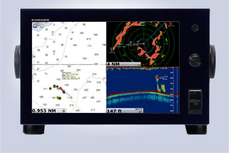
Furuno NavNet TZtouch TZT9 9" Multifunction Display
Features:
Sunlight Viewable 9" WVGA (800x480 pixels) multi touch display
Touch Screen with Multi Touch: Be more hands-on with our easy-to-understand touch screen interface
Easy to use RotoKey™
Home Key for immediate access to the menu and a carousel of your customized display configurations
Marine Weather Forecaster delivers unlimited access to completely free weather forecasts, worldwide, 24/7
Tablet & Smartphone Apps: Custom apps allow you to wirelessly view and control TZtouch from any iPhone, iPad, or iPod Touch (Other mobile platforms to be supported in the future.)
WiFi Hotspot Connectivity: TZtouch has WiFi connectivity, enabling the ability to download useful updates, such as real-time weather data, via the Internet
Anti-reflective glass coating is visible under any lighting condition.
Add Radar, Network Fish Finder, AIS, and a variety of other sensors
Built on an Ethernet network
NMEA2000 network interface
Network up to 6 TZtouch displays
Preloaded with FREE official NOAA raster and vector charts
Optional “C-Map by Jeppesen” and “Datacore by Navionics” vector cartography available for purchase
Dual SD Card slots
FREE high resolution satellite photos of US available for download
Save up to 30,000 user points, 30,000 ship’s track points and 1,000 planned routes with up to 500 waypoints per route
Furuno NavNet TZtouch TZT14 14.1" Multifunction Display
Features:
Sunlight Viewable 14.1" WXGA (1280x800 pixels) multi touch LCD display
Touch Screen with Multi Touch: Be more hands-on with our easy-to-understand touch screen interface
Easy to use RotoKey™
Home Key for immediate access to the menu and a carousel of your customized display configurations
Marine Weather Forecaster delivers unlimited access to completely free weather forecasts, worldwide, 24/7
Tablet & Smartphone Apps: Custom apps allow you to wirelessly view and control TZtouch from any iPhone, iPad, or iPod Touch (Other mobile platforms to be supported in the future.)
WiFi Hotspot Connectivity: TZtouch has WiFi connectivity, enabling the ability to download useful updates, such as real-time weather data, via the Internet
Anti-reflective glass coating is visible under any lighting condition.
Add Radar, Network Fish Finder, AIS, and a variety of other sensors
Built on an Ethernet network
NMEA2000 network interface
Network up to 6 TZtouch displays
Preloaded with FREE official NOAA raster and vector charts
Optional “C-Map by Jeppesen” and “Datacore by Navionics” vector cartography available for purchase
Dual SD Card slots
FREE high resolution satellite photos of US available for download
Save up to 30,000 user points, 30,000 ship’s track points and 1,000 planned routes with up to 500 waypoints per route
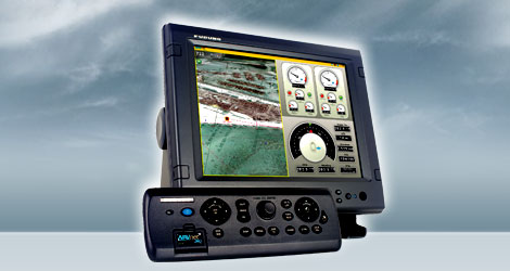
Furuno Navnet MFDBB 3D Black Box Multi Function Processor Without Display
Features:
Chart scaling without limitation
Pre-loaded with NOAA raster chart library for entire U.S. coastline including Alaska and Hawaii
TimeZero™ technology facilitates instant chart redraw, allowing zooming in and out, chart panning, changing chart display modes and other chart handling functions
seamlessly and with no lag time
Full Time 3D chart rendering. Choose a 2D top-down view of the navigation chart for a traditional chart plotting presentation, or choose to pan and zoom the chart to any angle at any range scale you choose
Pan the chart using the scroll pad, and then instantly return to own ship at the touch of a single dedicated key
Zoom seamlessly and continuously to whatever chart scale you desire - TimeZero™ architecture allows you to seamlessly zoom in or out to the exact magnification level
you like without steps or limitations
No “3D mode” to change into and no waiting - NavNet 3D operates in a 3D environment full-time
Fuse satellite photography with raster or vector chart information. Land areas (zero depth) are completely opaque, so that these areas are displayed as high-resolution satellite photos on the chart. As the depth increases, the satellite photography becomes more transparent so that you will know where the shallows end and the deeper
water starts, while allowing the raster or vector chart to be visible
More than 12,000 ship's track points and over 2,000 waypoints
200 planned routes, with up to 100 waypoints/route
Preloaded tides & currents
Engine monitoring
Built-in ARPA processor can simultaneously acquire and track up to 30 targets (with appropriate sensor)
AIS tracking when connected to AIS receiver
True color depth shading utilizing bathymetric data
Standard video input and outputs
Extended Mode feature of Navnet 3D Black Box allows you to connect two monitors and synch the video, or 'split' the two screens into eight different quarters to display the information you want to see mostOperate with Ethernet, NMEA0183 and NMEA2000®
All the NavNet 3D radar sensors incorporate a NMEA 2000® port to which certain NMEA2000® sensors can be directly connected
Power for NMEA2000 sensors supplied directly from the radar, allowing for flexible installation of multiple NMEA 2000® sensors without the need to run cables to the main processor unit
NMEA 2000® data is converted and distributed throughout the NavNet 3D Ethernet network
Easiest user interface on the market
Simple operation with a combination of both RotoKey™ and a familiar point-and-click cursor pad control
By turning a rotary knob on the control panel, RotoKey™ will be activated, giving you full access to NavNet 3D controls
A short press of the RotoKey™ gives you access to a user-selected set of the functions that you select upon installation from Basic, Standard, Full or Custom, while a longer press of the key displays all of the functions available
The power of the point-and-click interface allows for incredibly simple operation - click anywhere on the screen for context-sensitive options for that area. Click on any data box to access detailed information for that function. A variety of features can be accessed through a familiar left or right click interface
Connect a generic USB mouse to further simplify operation
Fully digitized environment with add-on components
Highly sensitive digital sensors for radar and fish finder, delivering total fusion of hardware and software
Ultra High Definition (UHD™) Digital Radar offers crystal clear, noise-free target presentation with automatic real-time digital signal processing
Real-time digital auto Gain/Sea/Rain controls to deliver noise-free radar presentation
Radar antenna rotation speed (24/36/48 rpm) is automatically shifted to the appropriate pulse length
Simultaneous scanning technology drives our powerful dual-range radar, providing unsurpassed target detection. With each sweep of antenna, dual progressive scan transmissions are sent, received and processed to display two separate radar ranges on your NavNet 3D display simultaneously. Each radar presentation acts autonomously, allowing for manipulation of individual gain and clutter controls
Sirius Satellite Weather overlays chart with highly accurate information, requires Sirius receiver and subscription
Optional Weatherfax/Navtex receiver available
External alarm output & point/MOB alert input
Control up to 4 AXIS IP cameras
Furuno MU170C 17 inch Color Monitor
Features:
Crystal clear 17" marine grade monitor for use as main or remote display
Resolution: 1280 x 1024 SXGA
1000 cd/m2 brightness and scratch resistant A/R coating allows superior viewability in direct sunlight
Wide range of inputs: 2 RGB analog, 1 Digital Video Interface (DVI-D) and 3 NTSC/PAL
Fully dimmable
Any three of the NTSC inputs are PIP (Picture-In-Picture) capable with adjustable size and screen location
I/R Remote control included as standard supply
Table Top or Flush Mountable (table top mounting bracket is optional)
Waterproof Tested to IPX5 standard (from front)
Customizable input names for easy on-the-fly identification and switching between onboard radar, sonar, sounder, camera, etc.
Exceptional viewing angle, (left/right 80 degrees, up/down 75 degrees)
Automatic signal input recognition and scaling for easy setup and installation
Dedicated push-buttons for changing monitor inputs and PIP source eliminates confusing menus
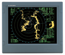
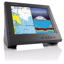
Furuno MU231 23.1 inch Color LCD Monitor Without Bracket
The MU231CR display unit, used with the FAR28X7 Series Radar, employs a 23.1” DVI-D LCD which provides an effective picture diameter of larger than 340 mm. The SXGA monitor provides crisp radar images, which are presented in a selectable color with a day and night background color for easy observation in all lighting conditions. Different colors are assigned for marks, symbols and texts for user-friendly operations.
Features:
Crystal clear 23.1" marine grade monitor for use as main or remote display
Resolution: 1200 x 1600 (SXGA)
Effective picture diameter of larger than 340mm
Selectable color combinations with day and night background colors for easy observation in all lighting conditions
Features:
Crystal clear 23.1" marine grade monitor for use as main or remote display
Resolution: 1200 x 1600 (SXGA)
Effective picture diameter of larger than 340mm
Selectable color combinations with day and night background colors for easy observation in all lighting conditions
